Feeds:
Posts
Comments

Posts Tagged ‘severe weather’

UPDATE 10/28/20 1:15 p.m.: The tropical storm watch has been upgraded to a tropical storm warning. A tropical storm warning means tropical storm-force winds are expected somewhere within this area within the next 36 hours.

The National Weather Service in Peachtree City has advised of the potential for severe weather conditions tonight into Thursday due to Tropical Storm Zeta.

Currently, much of north and west Georgia are under a tropical storm watch as well as a flash flood watch until midday on Thursday, 10/29. The main impacts include:

• Heavy Rain (widespread 2-4 inches)

• Flooding and flash flooding

• Strong and Damaging Winds (could down trees/power lines)

Here are ways you can get prepared now:

  • Keep updated on the latest weather by tuning in to your local weather channel and downloading a weather notification app so that it will notify you when a television or radio isn’t nearby.
  • Sign up for the City’s Smart911 notification system to receive emergency weather alerts should your property be included in a storm predicting polygon.
  • Determine a safe place to shelter in the event of damaging winds or a tornado. Look around your place for helmets, pillows, e.g. anything you can use to protect your head in the event of flying objects in high winds. As always, it’s good to be on the lowest floor of a house or structure since winds are less strong near the surface.
  • Charge your devices including smartphones, laptops, etc. now, and leave them charging. 
  • Clear sidewalks and drains near your property of fallen leaves; however, do not push into the street as the additional material in the roadway could block storm water drains.

Read Full Post »

The National Weather Service has issued Tornado Watch #498 for DeKalb County (and may others) until 9PM tonight.

A tornado watch means that conditions are favorable for tornados to occur. Stay tuned to a weather radio, a local TV/radio station or a weather app for updates.

If you hear the tornado sirens today, seek shelter immediately.

Read Full Post »

The National Weather Service in Peachtree City has advised of the potential for severe weather conditions tonight into Thursday due to Tropical Storm Sally.

Currently, much of north and central Georgia are under a wind advisory as well as a flash flood watch. The main impacts include:

• Heavy Rain (Widespread 3-8 inches possible)

• Flooding and flash flooding. (The watch is in effect until 8 AM on Friday, 9/18)

• Strong and Damaging Winds (Could down trees/power lines)

Here are ways you can get prepared now:

  • Keep updated on the latest weather by tuning in to your local weather channel and downloading a weather notification app so that it will notify you when a television or radio isn’t nearby.
  • Sign up for the City’s Smart911 notification system to receive emergency weather alerts should your property be included in a storm predicting polygon.
  • Determine a safe place to shelter in the event of damaging winds or a tornado. Look around your place for helmets, pillows, e.g. anything you can use to protect your head in the event of flying objects in high winds. As always, it’s good to be on the lowest floor of a house or structure since winds are less strong near the surface.
  • Charge your devices including smartphones, laptops, etc. now, and leave them charging. 

Read Full Post »

Due to forecasted rains and potential thunderstorms tomorrow as well as the need to change the batteries on a few of the current sirens, we have decided to move the monthly test of the tornado outdoor warning system until next Wednesday, February 14th at 5:00 p.m.  However, as this is Severe Weather Awareness Week for the entire state, you may hear sirens on Friday, February 9th around 9 a.m. during the statewide tornado drill.

If you have questions or want more information about the siren system, check out the Siren page on the City’s website or contact Police Lt. Barry Woodward at 404-373-6551.

siren

Read Full Post »

February 5-9 is Severe Weather Awareness Week in Georgia. Take some time this week to check out the resource materials on the Ready Georgia website that will help you and your family get prepared for weather emergencies. And if you’re looking for Decatur specific information, be sure to check out the 2016-2017 Emergency Services Supplement from the Decatur Focus. (This guide will be updated in November 2018.)

SevereWeather

Read Full Post »

Due to the threat of severe weather tomorrow, the April test of the tornado outdoor warning siren system has been postponed until Thursday, 6 April 2017 at the regular time of 5:00 p.m. The test should last approximately one minute.

SevereWeather

If you have questions or want more information about the siren system, check out the Siren page on the City’s website or contact Police Lt. Barry Woodward at 404-373-6551.

Read Full Post »

The National Weather Service and Georgia Emergency Management Agency in conjunction with several other state and local partners will recognize next week (February 6-10, 2017) as Severe Weather Preparedness Week.

SevereWeather

Severe weather is no stranger to Georgia as many state residents recently experienced a significant outbreak during January 21-22, 2017, where a record-breaking 41 tornadoes affected much of central and southern Georgia. Severe Weather Preparedness Week is an excellent opportunity to learn more about the dangers of severe weather, as well as knowing how and when to take proper actions when severe weather is expected and hits.  Please take the time now, to review your home/school/businesses preparedness plans as each day is dedicated to a different topic that addresses severe weather preparedness.

Make sure to check out the NWS website and the City’s Facebook page throughout the week for more information on several topics, including:

  • Monday, February 6: Family Preparedness
  • Tuesday, February 7: Thunderstorm Safety
  • Wednesday, February 8: Tornado Safety
  • Thursday, February 9: Lightning Safety
  • Friday, February 10: Flash Flooding/Flood Safety

You can also check out the 2016-2017 edition of the City’s Emergency Services Guidebook for more information on how to prepare for Decatur specific threats.

Read Full Post »

There are trees down around the City of Decatur this morning, and some residents, businesses and schools are without power.

The current list of known downed trees and limbs in the City of Decatur, in no particular order:

  • 198 Avery Street
  • 453 S. Columbia
  • 435 & 439 E Lake Drive
  • 114 Olympic Place
  • 928 3rd Avenue
  • 116 Landsdowne
  • 351 S. Mcdonough
  • 928 3rd Avenue
  • 923 S. Candler Street
  • 919 S. Candler Street
  • Oakview and Sring Street
  • Mountainview & Sycamore Street
  • 803 Ponce de Leon
  • 116 Hurron

For the latest weather updates from the City Schools of Decatur, please visit the CSD website.

Please read through the severe weather tips posted yesterday if you have not done so already. It includes important phone numbers and information about registering for Code Red and Smart911.

GEMA’s One Minute Weather Outlook for Tuesday, April 29, 2014:

Hazardous Weather Outlook

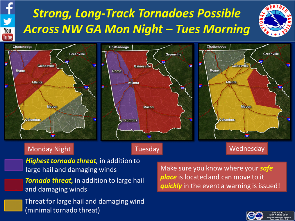
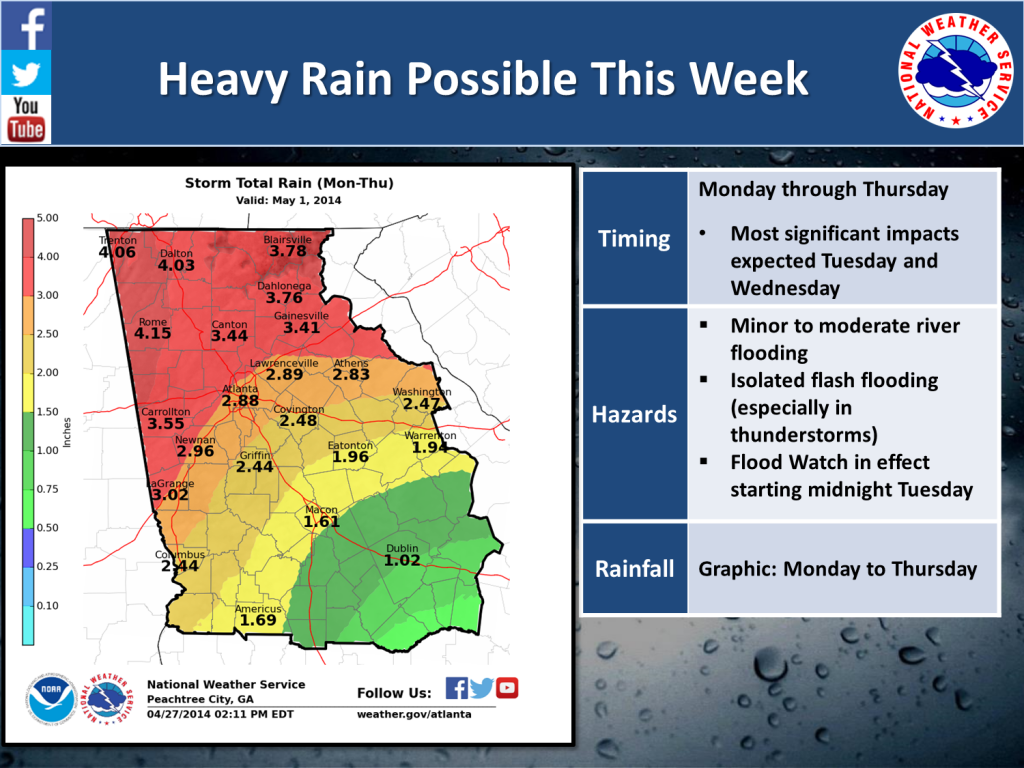
Scattered showers to severe storms are expected to move east across Georgia this afternoon into tonight. The combination of moderate instability and strong wind shear could produce damaging winds and even the possibility of tornadoes. The strong and gusty winds from thunderstorms will have the potential to bring down trees that were weakened by the recent ice storms. Some severe storms may produce large hail and frequent cloud to ground lightning. Minor to significant river flooding will continue. A Flash Flood Watches is in effect for portions of far northeast and southwest Georgia through Wednesday evening.

Flood Warnings continue for the following rivers and creeks in Georgia:

Alapaha River at Statenville affecting Echols County
Altamaha River at Baxley affecting Appling, Tattnall, Toombs, and Wayne Counties
Altamaha River at Everett City affecting Glynn, McIntosh, and Wayne Counties
Ogeechee River near Eden
Satilla River at Atkinson affecting Brantley County
Savannah River near Clyo

Today:

Expect occasional showers and thunderstorms. Some storms may be severe. Highs will range from 70 to 90.

Tonight will have a chance of showers and thunderstorms in the evening. Expect occasional showers and thunderstorms after midnight with lows ranging from 58 to 71.
Wednesday will have occasional showers and thunderstorms with highs ranging from 68 to 88.
Thursday will be mostly cloudy with a chance of showers and thunderstorms in the south. Temperatures will range from lows between 50 and 68 to highs between 68 and 82.

Extended Weather Outlook:

Weather Links:

National Hurricane Center: http://www.nhc.noaa.gov
National Weather Service: http://www.nws.noaa.gov
NWS Mobile: http://mobile.wrh.noaa.gov
Get Free Weather Alerts: http://inws.wrh.noaa.gov
Mobile GEMA One Minute Weather Outlook: http://gema.ga.gov/weather
GEMA’s One Minute Weather Outlook – Real Simple Syndication (RSS) Feed: http://www.gema.ga.gov/rss_generator.nsf/rss?openagent&uid=BA93D066C88B8164852574F0006626EA

Disclaimer: The information in this document is based on the latest forecast provided by the National Weather Service at the time this document was sent to the recipients. The National Weather Service will update their information and graphics as situations dictate. Please check with your local National Weather Service for the most current information for your area.

State Warning Point
Georgia Emergency Management Agency
Phone: 1-800-TRY-GEMA
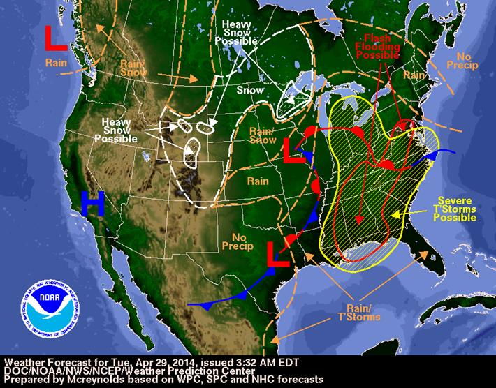
NOAA 4.29.14

Read Full Post »

nws 4.28.14

The latest weather update from DEMA / National Weather Service shows Decatur should be prepared for storms overnight and into the early morning. As of this posting, models are showing that the strongest part of the storm will most likely hit during the Tuesday morning rush hour. Everyone is urged to check the weather before getting on the road to go to work tomorrow morning.

As a reminder, turn your weather radio on and keep your phone close for Code Red/Weather Warn messages. Have a plan to take care of your family as well as your pets. Please don’t leave your pets outside during severe weather.

There is the possibility of tornados, hail and flash flooding in and around the City of Decatur. The community is urged to stay off the roads if possible once the heavy rain and thunderstorms start. Severe weather could continue in the area through Thursday.

Updates will be posted here as the weather situation develops.

Read Full Post »

Severe weather is expected to arrive in Decatur between 6 and 8 p.m. tonight and will last through Thursday. Tornadoes, flooding, severe thunderstorms and lightning are all possible during this time.

Here are things to do NOW to prepare for the inclement weather:

  • Make sure you have enough emergency food and water supplies to last for three days per person. If you have pets, make sure you have the necessary supplies to feed and care for them.
  • Register your phones for the Code Red Weather Warnings. This system will alert you to the dangers of severe weather and any other emergencies that require quick notification.
  • Create or update your Smart911 profile. Be sure to include any special medical concerns, especially if anyone in your household requires medical equipment that uses electricity.
  • Review your family’s emergency plan, and remind everyone where the safest place to shelter in your house is.
  • Charge all cell phones and put fresh batteries in emergency radios.
  • Download the FEMA smartphone app for additional tips and emergency information.

Remember:

  • Always remain calm.
  • Power outages or trees on power lines should be reported directly to Georgia Power at 1-888-891-0938.
  • The police non-emergency number is 404-373-6551.
  • Have a plan to check on any vulnerable neighbors (for example, seniors or those with medical conditions) during and after the storm.
  • When contacting loved ones, a text message is more likely to get through in an emergency situation than a phone call.

Tornado sirens: What you need to know

Decatur has installed four outdoor sirens to warn the community when such a threat occurs. The sirens are located at Glennwood Academy, Winnona Park Elementary, Oakhurst Elementary and the City Schools Administration Building on Scott Boulevard.

What are Tornado Outdoor Warning Sirens?

They are alarms that will be sounded to alert citizens who are outdoors that a tornado may be imminent. They are not designed to be heard inside a home or other building.

Who decides to sound the sirens and when will I hear them?

Sirens will be sounded by personnel in Decatur’s Police Communications Center when the National Weather Service issues a tornado warning for the Decatur area or when a tornado is spotted by a member of public safety. The sirens will sound for three to five minutes.

What should I do when I hear the siren?

Take immediate cover. Go indoors to a safe room at ground level or below with as few windows as possible. Basements are usually the best option. If you are in a vehicle and see a tornado approaching, get out immediately and go to the lowest floor of a sturdy, nearby building. If a building is not available, lie flat in a nearby ditch or depression and cover your head with your hands. Be aware of the potential for flooding. Do not get under an overpass or bridge. You are safer in a low, flat location. Never try to outrun a tornado in urban or congested areas in a car or truck. Instead, leave the vehicle immediately for safe shelter. Watch out for flying debris. Flying debris from tornadoes causes most fatalities and injuries. Stay in a safe place until the weather improves.

How will my family be alerted indoors and at night?

Everyone must take personal responsibility to monitor radio and television weather reports when severe weather occurs. In a crisis, the Emergency Alert System instantly interrupts radio and TV broadcasts to provide emergency information. The National Weather Service (NWS) uses the system to alert the public to emergency weather information and dangerous conditions. EAS warnings are also transmitted on National Oceanic and Atmospheric Administration (NOAA) Weather Radio. Since neither the sirens nor the media may alert you indoors at night, we recommend that households and businesses have a Weather Alert Radio, which sounds an alarm when the National Weather Service issues a tornado warning. If you buy a radio, we strongly recommend you purchase one that is programmable with your local county code.

More information about tornado safety can be found at http://www.ready.gov/tornadoes

Rainfall Amt Forecast

Read Full Post »

Older Posts »