Feeds:
Posts
Comments

Archive for the ‘Transportation’ Category

Parking coming soon image 400The new downtown Decatur parking meters have arrived and they’re getting installed next week. The PALs (Parking Attendant Liaisons) will be walking around showing people how to use the new machines. As the new pay stations are installed, the old meters will be covered with a blue bag and a sticker that says “Pay at Pay Station.”

New Parking Meter Basics:

• The new solar-powered pay stations and single meters accept Visa, MasterCard, and American Express credit or debit cards, as well as good old-fashioned nickels, dimes and quarters, and dollar coins too.

• Pay by cell accounts are also an option.

• “Pay Here” signs with directional arrows on each block will direct you to pay stations.

• You can pay for on-street parking at any of the pay stations regardless of location. All you need to do is remember your license tag number and enter it at the machine.

• A limited number of blocks continue to use single space meters but offer the same flexible payment options.

• The two hour parking limit still applies.

• If you need more than two hours, choose one of the many downtown parking decks identified with a “P” for a cost effective option.
Read Full Post »

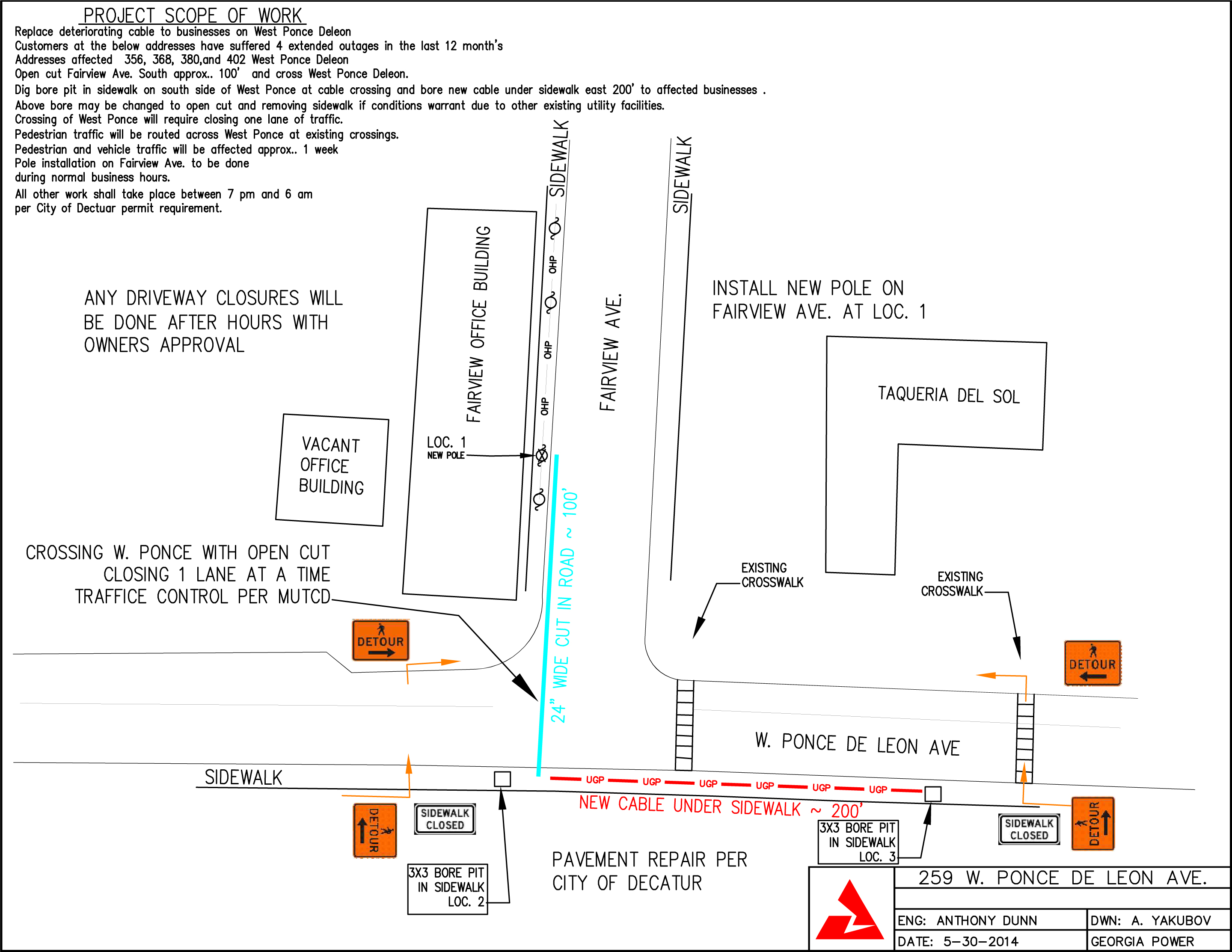
Georgia Power is expected to start utility work next week, most likely on Monday, June 9. This will impact the intersection of W Ponce de Leon Ave and Fairview Ave. During the day, work will take place between 9 a.m. and 4 p.m., Monday through Saturday. When the project gets to the point where it crosses W Ponce (blue line on the diagram below), there will be some overnight work  (7 p.m. – 6 a.m.) that will require street closures.

Georgia Power is required to notify nearby businesses of the pending work before it starts.

259-w-ponce-de-leon-ave_6


Read Full Post »

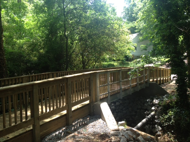
Derrydown bridge.Decatur2014.5.12.bThe Derrydown Bridge is now open! Funded through the City of Decatur’s Sidewalk Improvement Program, this new bridge restores a key connection across Shoal Creek between Poplar Circle and Derrydown Way. Senior Engineer John Madajewski of the City’s Design, Environment & Construction Division managed the project and Ohmshiv Construction, LLC of Lawrenceville constructed the bridge, which cost approximately $79,000.
Read Full Post »

2013 Bike DerbySgt. Jennifer Ross with the Decatur Police Department shares the following: 
Do you want to have your bicycle registered with the police department in case it is lost or stolen?

If so, please stop by the Children’s Bike Rodeo Saturday, May 17, 10 a.m. – 1 p.m. in the Callaway parking lot, located at the corner of West Trinity Place and Commerce Drive in downtown Decatur. Decatur Police will record the identifying information for your bicycle, apply a decal and photograph your bicycle so that in the event it is stolen, the needed information will be on file. Also, in the event the bicycle is found, it can be reunited with its owner. The process takes just a few minutes. Even if you are not attending the bike rodeo, please bring your bicycles by and get them registered.

Read Full Post »

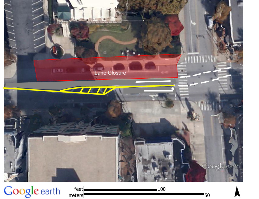
The contractor for Phase II of the 315 West Ponce construction project will be working this Saturday, May 10, to re-stripe the road according to the plan below. For the remainder of the project (approximately one year, or until May 2015) all vehicular traffic for the office will enter and exit off West Ponce de Leon. The drive through ATM will remain open. Construction staging and deliveries will be off of West Ponce de Leon.

The City of Decatur will collect traffic counts throughout the neighborhood in late May of this year through a private consultant. Also in late May, a landscaping meeting and Phase II construction timeline meeting will be scheduled.

Please contact Amanda Thompson, City of Decatur Planning Director, with any questions at 678.553.6513 or amanda.thompson@decaturga.com.315 Traffic Staging Plan May2014

Read Full Post »

The milling and paving of College Ave that was going to start on Wednesday has been postponed. Once the road work is rescheduled, an update will be posted here.


Read Full Post »

Starting on Wednesday of next week, milling and paving will occur on College Ave overnight between 9 p.m. and 5 a.m. Depending on weather conditions, the work could continue through the weekend. roadwork

Read Full Post »

storm water

Weather permitting, Reeves Contracting will mill and repave the 300 block of Church Street and the intersection of Church and East Trinity Place starting at 2 a.m. on the morning of Saturday, April 5. If all goes well, the work should be completed by early Saturday afternoon.

Should the weather prevent work on Saturday, the back-up dates are Wednesday or Thursday of the week of April 7.

Read Full Post »

2014 PGM Decatur Course MapReminder

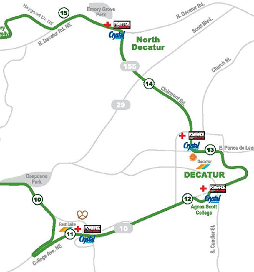
Don’t forget the 2014 Publix GA Marathon is this Sunday, March 23, 2014.  There will be road closures and delays along the route as it weaves through the city between 7:15 am – 11:00 am.  The marathon enters Decatur on West College Avenue at Park Place near the East Lake Marta Station and exits the city in the 1100 block of Clairemont Avenue near the Decatur YMCA.  Keep in mind the marathon starts and ends in downtown Atlanta and travels through parts of DeKalb County as well.

Decatur Road Closures:

  • West College Avenue from Park Place to East College Avenue and Commerce Drive
  • East Ponce de Leon Avenue from Commerce Drive to Clairemont Avenue
  • Clairemont Avenue from East/West Ponce de Leon Avenue to Commerce Drive

Decatur Lane Closures:

  • Commerce Drive from East College Avenue to East Ponce de Leon Avenue
  • Clairemont Avenue from Commerce Drive to North Decatur Road

There will be traffic delays around the course throughout the duration of the marathon. The runners have the right-of-way at all times and no traffic will be released if it could impede the runners.  Traffic will not be permitted to turn onto roads that are closed and will only be allowed to cross at certain points when doing so will not impede the runners.  Traffic will be permitted onto the roads with partial lane closures when doing so will not impede the runners.  Please understand that even if you are travelling on a road that is not part of the course but crosses the course or is near the course, you will experience delays.  Please check your schedules and the course maps and plan accordingly.

The Bright Side

We are about the halfway point for the runners and regularly receive feedback about how great it feels to come through Decatur and have so many people cheering.  Aside from the fixed cheering stations at West College Avenue & Mead Road, Fellini’s on Commerce Drive and in front of the Old Courthouse on East Ponce de Leon Avenue, it is not uncommon for residents to pop up along the route and cheer.  So if you have Sunday morning plans that require driving, plan on heading out earlier or later or plot an alternate route.  If you have no plans that require driving, it’s a great day to walk into downtown Decatur for errands, brunch and to cheer!

Read Full Post »

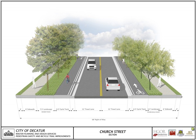
web-Church Street Section-2014-03-19

Here is the text from a fact sheet handed out at last night’s workshop:

CLAIREMONT AVENUE/COMMERCE DRIVE/CHURCH STREET
PEDESTRIAN SAFETY AND BICYCLE TRAIL IMPROVEMENTS
FACT SHEET
March 19, 2014

“Complete Streets” per the City of Decatur Community Transportation Plan
• Following the “complete streets” concept, the existing corridor is rebuilt to accommodate bike and pedestrian travel modes.
• Use of smaller radii at all four corners of the intersection to reduce the length of the pedestrian crossing, thus reducing the exposure of pedestrian to vehicular traffic.
• Narrow the travel lane width from 12-feet to 11-feet.

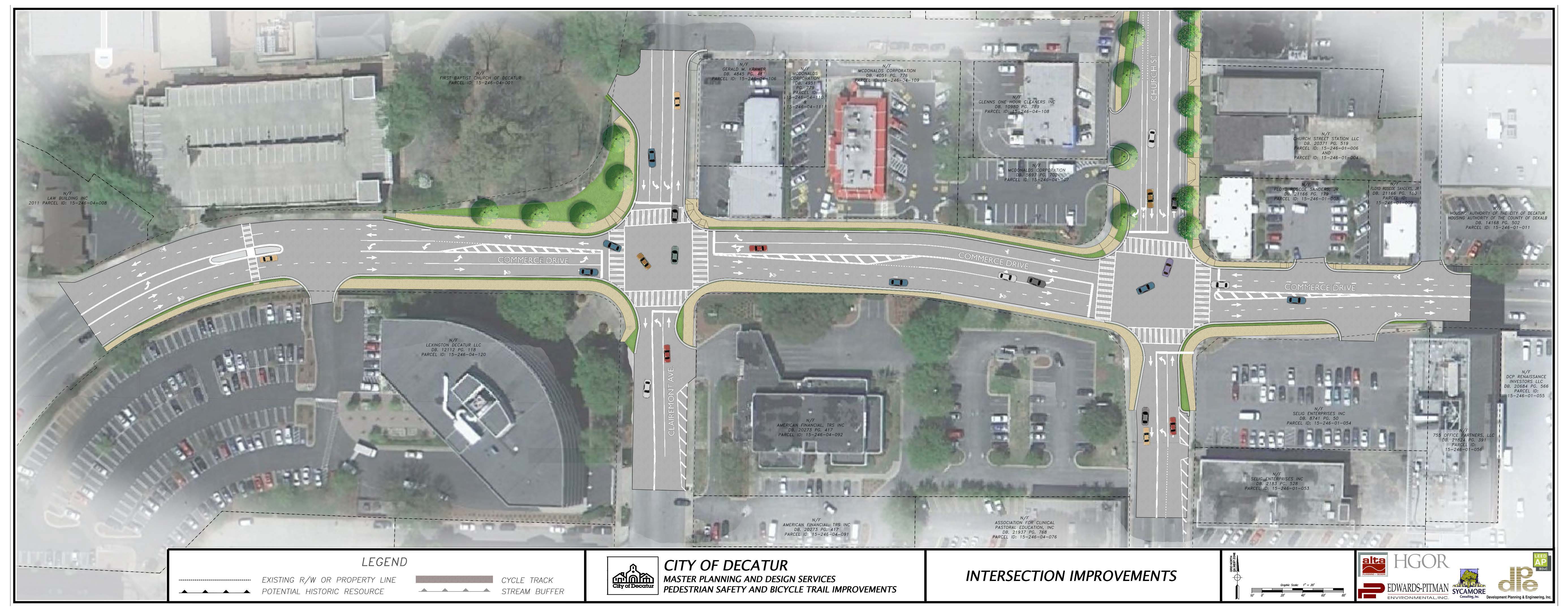
Clairemont Avenue and Commerce Drive Intersection
• Remove the southbound right turn lane and share it with the through lane.
• Remove the northbound right turn lane and share it with the through lane.
• Reduce from two eastbound through lanes to one through lane.
• Remove the westbound left turn lane and share it with the through lane.
• Use of smaller radii at all four corners of the intersection to reduce the length of the pedestrian crossing, thus reducing the exposure of pedestrian to vehicular traffic.
• Pedestrian crossing times reduced up to 40% (reduced from 27 seconds to 16 seconds).
• Narrow the travel lane widths from 12-feet to 11-feet.
• Add “bulb-outs” at corners of the intersection, where practical.
• Widen the sidewalks.
• Outside lanes will be “Shared Lanes”.

Church Street and Commerce Drive Intersection
• Remove one through southbound lane.
• Remove one through northbound lane.
• Remove the westbound left turn lane.
• Use of smaller radii at all four corners of the intersection to reduce the length of the pedestrian crossing, thus reducing the exposure of pedestrian to vehicular traffic.
• Pedestrian crossing times reduced up to 40% (reduced from 27 seconds to 15 seconds).
• Narrow the travel lane widths from 12-feet to 11-feet.
• Add “bulb-outs” at corners of the intersection, where practical.
• Widen sidewalks.

Church Street
• Incorporate One-Way Cycle Track on each side of Church Street.
• Incorporate sidewalk along each side of Church Street
• Incorporate greenspace between the One-Way Cycle Track and the sidewalk.
• Provide shade tree and landscape plantings along the western side of Church Street
• Provide understory tree and landscape plantings along the eastern side of Church Street

11025-Church-Commerce Intersection Graphics-2014-03-18

Read Full Post »

« Newer Posts - Older Posts »